Bhutan  Snowman Trek

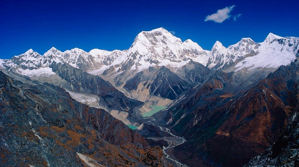
Bhutan  Snowman Trek is an extension of the beautiful Laya Gasa Trek and leads from Laya into the high altitudes of the Bhutanese Himalayas. It takes tough and enduring trekkers into the Lunana region and further on to Gangkhar Puensum and Bumthang or down to Sephu in the Trongsa district, depending on which route you choose.

The Snowman trek leads through the most remote areas up to very high altitudes. Trekkers have to camp in altitudes above 5,000m more than once, and depending on the seasonal temperatures, the camps are sometimes on snow.

Bhutan  Snowman Trek short itinerary,
Day 1: Arrival in Paro 2200 meters and stay overnight at Hotel
Day 2: Hike to Tiger’s Nest Overnight at Hotel
Day 3: Drive and trek to Gunitsawa village SharanZampa(40min, 80m descent, 2580m) Overnight at Camp
Day 4: Trek to Thangthangkha(22km, 7-8hrs, 770m ascent, 10m descent, 3610m) Overnight at Camp
Day 5: Trek to Jangothang (19km, 5-6hrs, 480m ascent, 4080m) Overnight at Camp
Day 6: Acclimatization Day in Jangothang Halt Overnight at Camp
Day 7: Trek to Lingshi (18km, 6-7hrs, 840m ascent, 870m descent, 4010m) Overnight at Camp
Day 8: Trek to Chebisa (10km, 5-6hrs, 280m ascent, 410m descent, 3880m) Overnight at Camp
Day 9: Trek to Shomuthang (17km, 6-7hrs, 890m ascent, 540m descent, 4220m) Overnight at Camp
Day 10: Trek to Robluthang(18km, 6-7hrs, 700m ascent, 760m descent, 4160m) Overnight at Camp
Day 11: Trek to Limithang (19km, 6-7hrs, 850m ascent, 870m descent, 4140m) Overnight at Camp
Day 12: Trek to Laya (10km, 4-5hrs, 60m ascent, 340m descent, 3840m) Overnight at Camp
Day 13: Rest and acclimatization day in Laya Overnight at Camp
Day 14: Trek to Rhoduphu (19km, 6-8hrs, 1,030m ascent, 750m descent,4160m) Overnight at Camp
Day 15: Trek to Nerethang (17km, 5-6hrs, 740m ascent, 4900m) Overnight at Camp
Day 16: Trek to Tarina (18km, 5-6hrs, 270m ascent, 1200m descent, 3970m) Overnight at Camp
Day 17: Trek to Woche (17km, 6-7hrs, 270m ascent, 330m descent, 3910m) Overnight at Camp
Day 18: Trek to Lhedi (17km, 6-7hrs, 980m ascent, 1190m descent, 3700m) Overnight at Camp
Day 19: Trek to Thanza (17km, 7-8hrs, 450m ascent, 4150m) Overnight at Camp
Day 20: Rest day at Thanza Overnight at Camp
Day 21: Trek to Danjit (8km, 3-4hrs, 80m ascent, 4230m) Overnight at Camp
Day 22: Trek to Tshochena (12km, 5 - 6hrs, 980m ascent, 240m descent, 4970m) overnight at Camp
Day 23: Trek to JichuDramo (14km, 4 - 5hrs, 230m ascent, 150m descent, 5050m) overnight at Camp
Day 24: Trek to Chukarpo (18km, 5 - 6hrs, 320m ascent, 730m descent, 4600m) overnight at Camp
Day 25: Trek to ThampeTsho (18km, 5 - 6hrs, 400m ascent, 700m descent, Overnight at Camp 4300m)
Day 26: Trek to Maurothang (14km, 5hrs, 330m ascent, 1020m descent, 3610m) Overnight at Camp
Day 27: Trek to Sephu (18km, 5 - 6hrs, 990m descent) Drive to Punakha and stay overnight at Hotel  
Day 28: Drive to Thimphu and stay overnight at Hotel
Day 29: Drive to Paro and stay overnight at Hotel
Day 30: Departure

Bhutan  Snowman Trek Detail Itinerary

DAY
  • 1

    Upon arrival at Paro International airport, you will be met by your guide. In the afternoon, you will have an opportunity to explore the beautiful town of Paro.

    Altitude 2200 m
    Meals Breakfast, Lunch, Dinner
    Accommodation Hotel
  • 2

    After breakfast, we will drive you to the trailhead to commence a climb through a beautiful pine forest. We will stop for light refreshments at the Taktsang cafeteria before walking on to the famous, Taktsang monastery or Tiger’s Nest. The primary Lhakhang or main temple was built around Guru Rimpoche’s meditation cave in 1684 by the Penlop of Paro, Gyalse Tenzin Rabgay. This incredible monastery clings to the edge of a sheer rock cliff that plunges 900m into the valley below. Legend has it that Guru Padmasambhava, the tantric mystic who brought Buddhism to Bhutan in 747 AD, flew here on the back of a flying tiger, DorjiDrolo from KurtoeSingyeDzong in the east. After lunch, visit Ta Dzong (built-in 1656 and renovated in 1968), an ancient watchtower, which now houses the National Museum. Below the museum is the RinpungDzong (literally meaning “Heap of Jewels”), the center of civil and religious authority in this valley, built-in 1646 by ZhabdrungNgawangNamgyal.

    Altitude 2200 m
    Meals Breakfast, Lunch, Dinner
    Accommodation Hotel
  • 3

    After breakfast, drive to DrugyalDzong, a ruined fortress 16km from Paro town. Although it is now in ruins, this dzong has great historical importance for the people of Bhutan. It was a place where the Bhutanese finally defeated the Tibetan invasion. On a clear day, you can view sacred Mt. Jomolhari (Mountain of Goddess) at an altitude of 7329m. The 25-day trek begins at Gunitsawa Village where you pass the army post. The campsite is on the opposite side of the river, not far from Gunitsawa.

    Altitude 2580 m
    Meals Breakfast, Lunch, Dinner
    Accommodation Camp
  • 4

    On this long day, the trail continues with lots of small ups and downs following the river through a heavily forested area with a few isolated farmhouses. After going uphill through the river valley, the valley finally narrows gradually to a mere path which descends to a meadow where a camp will be set up. From here, if weather permits, you have the first great view of Mt. Jomolhari.

    Altitude 3610 m
    Meals Breakfast, Lunch, Dinner
    Accommodation Camp
  • 5

    If you did not see Mt. Jomolhari the previous evening, you will still have a chance to get a great view early this morning. This morning the trek continues up the ParoChhu valley that widens into patches of alpine meadow and scanty growths of forest. You will cross an army checkpoint along the way and enjoy a spectacular view of high mountain ridges and snow-capped peaks. In this area yaks and their herders’ homes become a regular feature of the landscapes. Passing the villages of Soe, Takethang, and Dangochang is another asset on this day. After reaching Jangothang, one of the most beautiful campsites of the Himalayas, you will again have a spectacular view of Mount Jomolhari.

    Altitude 4080 m
    Meals Breakfast, Lunch, Dinner
    Accommodation Camp
  • 6

    The rest day in Jangothang provides plenty of possibilities for day hikes with great views of lakes and snow-capped mountains such as Jomolhari and Jichu Drake. There are good chances to spot some blue sheep on the upper slopes of the valley. Jangothang is a perfect environment for your acclimatization. You can also trek up to Tosoh or hike around the area. There are good short hiking trails in three directions. Jomolhari and its subsidiary mountain chains lie directly to the west, Jichu Drake to the north and there are a number of unclimbed peaks to the east.

    Altitude 4080 m
    Meals Breakfast, Lunch, Dinner
    Accommodation Camp
  • 7

    This is one of the longest days of the trek. A Short distance from the camp the trail begins climbing rapidly for about half an hour and then becomes a gradual ascent to the Nyilila pass at 4870m. While on the climb enjoy the surroundings. You might see herds of blue sheep grazing on the slopes of the mountains. From the pass you will have spectacular views of Mt. Jomolhari, Jichu Drake and Tsherimgang, all of them rising above 7000m. It’s a gradual descent to the camp where you will pass by some yak herders’ tents, made from yak wool. The herders use these tents while traveling to various pastures for their yaks. As you come down into the Lingshi basin, a beautiful U-shaped valley, you get a wonderful view of LingshiDzong on clear days. Tsherimgang and its glaciers rise up at the north end of the valley. The campsite is next to a stone hut you reach just before LingshiDzong.

    Altitude 4010 m
    Meals Breakfast, Lunch, Dinner
    Accommodation Camp
  • 8

    Today is the shortest walking day, and you can really take it easy. Shortly after starting you will reach a chorten below LingshiDzong. Here, you have the choice of staying on the main trail or taking a detour up to the LingshiDzong (4220m), which sits right atop a high ridge. In addition to a very special atmosphere of mystic tranquility, LingshiDzong provides a great view over the valley. After LingshiDzong you will be passing the villages of Lingshi and Goyul. In Goyul, the stone houses are clustered together to form a small compact village that is unusual in Bhutan where settlements are usually scattered. On reaching the campsite at Chebisa you will have plenty of time to visit the village houses if you feel up to it. There is also a beautiful waterfall located behind the village that is worth visiting.

    Altitude 3880 m
    Meals Breakfast, Lunch, Dinner
    Accommodation Camp
  • 9

    The morning starts with a long ascent behind Chebisa Village (2-3hrs) through a wide pastureland towards Gobu La pass (4410m). On the way, you will see a few people herding yaks. There is also a great chance to spot large herds of blue sheep above the trail. After crossing Gobu La pass, you descend into the valley, then climb again a little bit, before descending again to Shakshepasa (3890m), a large U-shaped valley. Climbing from here you will finally reach the campsite at Shomuthang, above a river, which is a tributary of the Nochu River.

    Altitude 4220 m
    Meals Breakfast, Lunch, Dinner
    Accommodation Camp
  • 10

    You begin by climbing up the valley to view Kang Bum (6526m) and some edelweiss. After two hours of climbing you will reach Jhari La (4750m) from where you catch the first glimpse of Sinche La (5005m), the pass you will have to cross the day after. The big snow peak in the north is Gangchhenta (6840m), better known as the Great Tiger Mountain. If the weather is clear, Tserim Kang and the top of Mt. Jomolhari will be visible. The camp by the river is called TsheriJathang and it is located in a beautiful wide and remote valley. Herds of takin, the Bhutanese National Animal migrate to this valley in summer and remain for about four months. The valley has been declared a takin sanctuary. Climb up a little bit and you will reach the campsite at Robluthang in a rocky meadow.

    Altitude 4160 m
    Meals Breakfast, Lunch, Dinner
    Accommodation Camp
  • 11

    The trek starts out with an initial 40-60 minutes ascent before gradually rising for another 1.5 hours through a boulder field. It is then a 1-hour steep ascent before reaching Sinche La pass (5005m) – the final and highest pass on this part of the trek. As you descend the far side of the pass you will see an impressive terminal moraine and a glacial lake at the foot of the valley. You can see classic examples of lateral moraines where the glacier has pushed rocks up both sides of the valley. Below the moraine, you cross KangoChhu and soon reach the Limithang campsite. The peak of Gangchhenta towers over the campsite even though it’s quite a distance away.

    Altitude 4140 m
    Meals Breakfast, Lunch, Dinner
    Accommodation Camp
  • 12

    Today, you walk downhill all the way along a narrow, winding river valley. After a long time, the trail takes you through a densely forested region. The trail leads you to the west side of Laya village. From the west of the village, you will have spectacular views of Mt. Gangchhenta and Mt. Masagang. In the village, centers are a community school and a basic health unit with a telephone connection.

    Altitude 3840 m
    Meals Breakfast, Lunch, Dinner
    Accommodation Camp
  • 13

    If you have trekked from the Paro Valley you should spend a day recuperating from the trek to Laya and preparing yourself for the rest of this challenging but spectacular trek. You should also walk up to Laya to acclimatize, and not just stay at the trail junction to Lunana. It’s worthwhile to stay one day in Laya just for the great views from Laya and its extraordinary inhabitants.

    Altitude 3840 m
    Meals Breakfast, Lunch, Dinner
    Accommodation Camp
  • 14

    From Laya, you descend to an army camp and continue following the river till the turn off point to Rhoduphu. After lunch, the climb continues through rhododendron bushes till you reach the camp at Rhoduphu just next to the RhoduChhu.


    Altitude 4160 m
    Meals Breakfast, Lunch, Dinner
    Accommodation Camp
  • 15

    After following the river for about half an hour you will have a steady climb to a high open valley at 4600m and then further up to Tsomo La (4900m). Tsomo La offers a superb view of Lunana, Mt. Jomolhari and Jichu Drake, and the Tibetan border. The route then crosses a flat, barren plateau at about 5000m. The campsite at Narethang is towered by the peak of GanglaKarchung (6395m).

    Altitude 4900 m
    Meals Breakfast, Lunch, Dinner
    Accommodation Camp
  • 16

    Distance18 kmTime5-6 hoursAscentAscent 270 m, descent 1,200 camp Altitude3,970 m. From the camp, you will climb for about an hour to GanglaKarchung La pass (5120m). The view from this pass is breathtaking and the whole range of mountains including Jekangphu Gang (7100m), Tsenda Kang and Tseri Gang (7300m) can be seen. The pass descends along a large moraine. Again one has great views: a massive glacier descends from Teri Kang to a deep turquoise lake at its foot. Up here a glacier lake burst through its dam in the early 1960s, causing widespread damage and partially destroying PunakhaDzong. Finally, it is a very long descent through thick rhododendron forest into the Tarina valley, where you will find several good campsites along the Tang Chhu.

    Altitude 3970 m
    Meals Breakfast, Lunch, Dinner
    Accommodation Camp
  • 17

    The walk leads down through conifer forests following the upper ridges of the Pho Chhu, passing some impressive waterfalls. The trail then climbs over a ridge and drops to Woche, a settlement of a few houses, the first village in the Lunana region.

    Altitude 3910 m
    Meals Breakfast, Lunch, Dinner
    Accommodation Camp
  • 18

    The trek starts through juniper and fir forests, and further ahead, through rhododendron bushes. Climb up to Keche La pass (4650m) where one can have a great view of surrounding mountains again. After the pass, descend to the riverside walking through a village with a stunning view of Table Mountain and others. Follow up on the river till Lhedi Village. Lhedi has a basic health unit, a school, and a wireless telephone connection.

    Altitude 3700 m
    Meals Breakfast, Lunch, Dinner
    Accommodation Camp
  • 19

    In clear weather, you will have great views of Table Mountain (7100m). Around lunchtime, you will pass the small village of Chozo (4090m) which has a dzong still in use. Reaching Thanza you will have a great view of Table Mountain which forms a 3000m high wall of snow and ice behind the village. Although there are possibilities to camp directly at Thanza, most groups prefer to camp in Thoencha.

    Altitude 4150 m
    Meals Breakfast, Lunch, Dinner
    Accommodation Camp
  • 20

    In Thanza walk around and experience some village life or climb up the ridge for fascinating views of lakes and mountains. But as it takes time to arrange fresh yaks for the rest of the trek, you might have to spend one day at Thanza anyway.

    Altitude 4150 m
    Meals Breakfast, Lunch, Dinner
    Accommodation Camp
  • 21

    From Thoencha, the trail climbs up to a large boulder from where you will have excellent views of Thanza, Thoencha and Choso village, and the surrounding mountains. After a few hours of relatively flat and easy walking, you will reach a yak meadow with some yak herders’ huts. It is an excellent campsite with a great chance to spot some blue sheep on the hills above. A trail junction near the campsite will give you the choice between the routes up to GangkarPuensum base camp, and further on to Bumthang or to Sephu (Trongsa).

    Altitude 4230 m
    Meals Breakfast, Lunch, Dinner
    Accommodation Camp
  • 22

    Having chosen the route to Sephu, the trek crosses a creek and after a long climb, you will reach Jaze La (5150m) with spectacular panoramic mountain views. The path then descends between snow-covered peaks and a couple of small lakes to the campsite near the shore of Tshochena Lake.

    Altitude 4970 m
    Meals Breakfast, Lunch, Dinner
    Accommodation Camp
  • 23

    You follow the banks of the blue-green lake before arriving at a ridge at 5100m, where there is another spectacular view in all directions. After going up and down over small hills to reach a glacial lake, the route descends first before climbing again up the next pass, the Loju La (5140m). Finally, after crossing a small saddle (5100m) you will enter a wide glacial valley from where the trail descends gradually to the campsite at JichuDramo.

    Altitude 5050 m
    Meals Breakfast, Lunch, Dinner
    Accommodation Camp
  • 24

    Right after leaving the camp you will climb through a moraine to Rinchen Zoe la (5320m). Spectacular mountain scenery with GangkarPuensum amongst the impressive mountains is the reward for climbing the highest pass on this trek route. Rinchen Zoe peak (5650m) towers above the pass the west. Descending from the pass, the route leads into a wide valley with several lakes and goes steeply down along a moraine to the ThampheChhu. Here the vegetation begins to thicken again and you will see the first real trees since Lhedi. After a couple of hours, you reach the campsite at Chukarpo.

    Altitude 4600 m
    Meals Breakfast, Lunch, Dinner
    Accommodation Camp
  • 25

    The descent continues along the river till you reach the yak herder huts at Gala Pang Chhu (4010m). From here the trail climbs steeply towards ThampeTsho, a beautiful clear turquoise lake, with the campsite next to it.

    Altitude 4300 m
    Meals Breakfast, Lunch, Dinner
    Accommodation Camp
  • 26

    From the lake, you climb steeply to the last pass on your trek, the Thampe La (4600m) with a good chance to spot some blue sheep on the way. Then the path descends to the sacred lake Om Tsho. Passing a waterfall you will reach another, smaller lake 100m below to descend steeply to the Nikka Chhu. The path finally leads through mixed forest to a large clearing on the banks of the river with a few yak herder huts at Maurothang.

    Altitude 3610 m
    Meals Breakfast, Lunch, Dinner
    Accommodation Camp
  • 27

    On the last day of this extraordinary trek, your porters will have to change from yaks to horses as the yaks will not be willing to go further down. The path follows the Nikka Chhu to reach a large grassy area overlooking the road and the villages of Sephu. You finally reach the road at the Nikka Chhu Bridge at Sephu where you will find several stores (mainly selling bamboo products) and small restaurants. From here, drive through to Punakha.

    Altitude 1242 m
    Meals Breakfast, Lunch, Dinner
    Accommodation Hotel
  • 28

    After breakfast, visit the impressive Punakha Dzong which was built by ZhabdrungNgawangNamgyal. For many years until the time of the second king, it served as the seat of the Government. Punakha is still the winter residence of Je-Khenpo.


    On the way, stop a while to view Chimi Lhakhang, which was built by Lama DrukpaKuenley (the Devine Madman) in the 15th century. He subdued the demoness with his “magical thunderbolt”. The temple is also known as “the Temple of Fertility”. Later drive to Thimphu with the journey taking about 3.5 hours via the Dochula Pass (3140 m).


    In the evening, visit TashichhoDzong, the seat of the national government and the Central Monastic Body which includes the summer residence of the Je Khenpo (Chief Abbot of Bhutan).

    Altitude 2334 m
    Meals Breakfast, Lunch, Dinner
    Accommodation Hotel
  • 29

    After breakfast, we will drive to Dodeyna to climb through a beautiful forest track to the Tango Monastery which overlooks a forested valley and other Buddhist retreats high in the mountains. Then we visit the National Memorial Chorten built in honor of Bhutan’s late King Jigme Dorji Wangchuck before visiting the mini zoo at Motithang to see the Takin, Bhutan’s national animal. If you wish we can then visit the Handicrafts Emporium followed by shopping for souvenirs and other items in the shops of Thimphu. In the evening drive through to Paro.

    Altitude 2200 m
    Meals Breakfast, Lunch, Dinner
    Accommodation Hotel
  • 30

    In the morning drive to Paro International Airport where your guide will accompany you to bid you farewell.

    Altitude 2200 m
    Meals Breakfast
    Accommodation No

Cost Includes

    • Arrival & Departure land transport.
    • 2 in sharing accommodation in Kathmandu with Breakfast. (3 nights)
    • All meals, while on tour in Bhutan including necessary land transport.
    • Experience guide and supporter driver/ porter.
    • Tented accommodation while on a trek with Mattress, table, and chair.
    • Entrance fee while sightseeing in Bhutan.
    • Bhutan visa fee.
    • Government taxes and service charges.

Cost Excludes

    • Nepal entry Visa Fee if entering Bhutan from Nepal.
    • Personal travel insurance.
    • Lunch, and dinner in Kathmandu.
    • Kathmandu – Bhutan – Kathmandu airfare.
    • Personal expenses like telephone, laundry, personal tips for driver, guide.

Cost & Date

Start Dates are your arrival date in Nepal and End Dates are the returning date from Nepal.

The set departure dates listed are specially quoted and specified for group joining option. Let us know if the set departure dates are not suitable for you- another dates which are suitable for you can certainly be added by us.

Upcoming Trip Departure

  • Guaranteed - Trip is Guaranteed to run
  • Available - Trip is available to run if minimum group size is filled
  • Limited - Only few space available
  • Booking Closed - Maximum group size is filled

Check Available Dates

Trip Start Date Trip End Date Price Status Book

Looking for a personalized experience? We organize a privately guided trip designed to fit your taste and interest. Please fill out the form below to get started.

Reviews ( 0 Reviews For This Package )

FAQs

$ 00 / Person
BOOK NOW
30 Days Bhutan
TRIP OVERVIEW
Bhutan  Snowman Trek
Altitude 5320 m
Bhutan  Snowman Trek
Region Bhutan
Bhutan  Snowman Trek
Difficulty Extreme grade
Bhutan  Snowman Trek
Group size 2+ Peoples
Bhutan  Snowman Trek
Best Season Mid June to Mid October

QUICK INQUIRY